Angola, Indiana
The City of Angola, population 8,702[4], is nestled among the glacial lakes of Steuben County, Indiana, nearby the northeastern corner of the state. This year marks Angola’s thirty-first consecutive year of distinction by the National Arbor Day Foundation as a Tree City USA, one of the longest-running streaks in the state[5]. The city’s tree board uses school outreach through fourth grade tree programs and middle school tree planting initiatives to bolster education and awareness surrounding the community forest[5].
Land Cover Classification
|
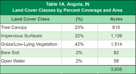
The City of Angola tree canopy is estimated to cover 815 acres and account for 23% of the city’s total land cover (Table 1A). Approximately 42% of the city’s land cover consists of grass and/or low-lying vegetation, and impervious surfaces such as buildings, roads, and other types of pavement cover 32% of total land area.
The greatest concentration of canopy cover is found in pockets near the city’s borders, particularly in the southern half of city limits. Conversely, the areas along N Wayne Street (Indiana 127), the main thoroughfare running north-south through the geographic median of the city, have the greatest amount of impervious surfaces (Figure 1A). |
|
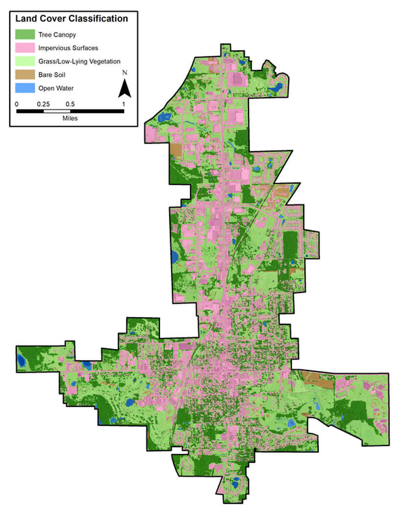
Figure 1A. Angola land cover classification.
To view this and other maps in an interactive format visit the Story Map
To view this and other maps in an interactive format visit the Story Map
Tree Canopy Related to Land Use
Tree canopy levels tend to correlate with land use types. Figure 2A illustrates a land use map of Angola, and Table 2A presents the various categories of land use as they relate to the five classes of land cover detailed in the previous section.
In most communities, commercial and institutional areas tend to have lower levels of tree canopy and higher levels of impervious surfaces than residential or agriculture/forested districts. This pattern holds true for the City of Angola; the percentage of canopy cover in commercial and institutional areas is 8% and 11%, respectively, while the percentage of impervious surfaces for the same areas is 55% and 52%, respectively. Agriculture/forested land contains the highest level of tree canopy cover at 51%, while residential areas are at 26% canopy coverage.
Opportunities should be pursued to increase canopy cover in commercial, institutional, and open space/recreational areas, suitable planting locations may be limited. High levels of impervious surface restrict available locations within commercial and institutional locations. Open space/recreational areas have an abundance of grass/low-lying vegetation (76%), which may seem ideal for planting, but likely represent maintained parks and playgrounds, sports fields, community gardens, or other areas intentionally cultivated or designed to have lower tree canopy levels. Residential areas present effective opportunities for new plantings, as engaged residents are receptive to planting efforts that produce results they can see and enjoy on a daily basis.
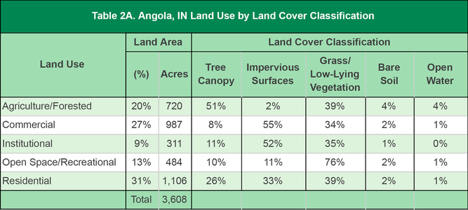
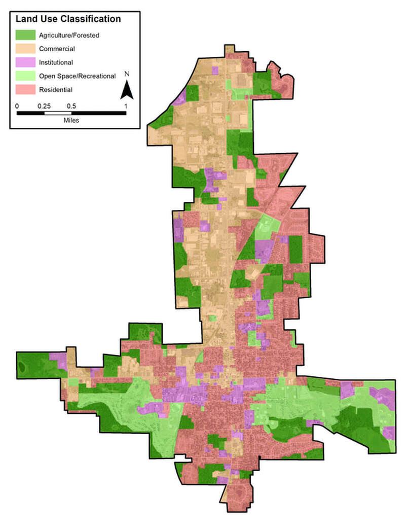
Figure 2A. Angola land use classification
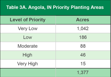
Priority Planting Areas
|
The priority planting analysis digs further into Angola’s land cover data in order to identify and prioritize potential areas for new tree plantings. Only grassy areas, open space, and bare soil were included in the analysis. Non-feasible planting areas, such as agricultural fields, recreational fields, major utility corridors, etc. were excluded from consideration. Once potential planting areas were identified, locations were assigned a priority ranking through an assessment of a variety of environmental features, including a given site’s proximity to hardscape and existing tree canopy, soil permeability, slope, soil erosion, floodplain proximity, and the urban heat island index.
|
|
The map of priority planting levels (Figure 3A) can be used to identify potential locations where new plantings may deliver the most impact in terms of ecosystem and community benefits. For example, Angola can use this map as a guide when deciding where future trees should be planted to have the greatest effect on lessening stormwater runoff. Of the city’s 1,377 plantable acres, 149 acres (11%) are assigned a planting priority of Moderate or above (Table 3A). If only these areas are planted, Angola’s canopy coverage would increase from 815 acres to 964 acres, increasing total tree canopy coverage to 27%.
The analysis reveals areas at Trine University with a priority ranking of High (surrounding the university bookstore) and Very High (dorm area) for potential planting areas that will optimize community benefits.
The analysis reveals areas at Trine University with a priority ranking of High (surrounding the university bookstore) and Very High (dorm area) for potential planting areas that will optimize community benefits.
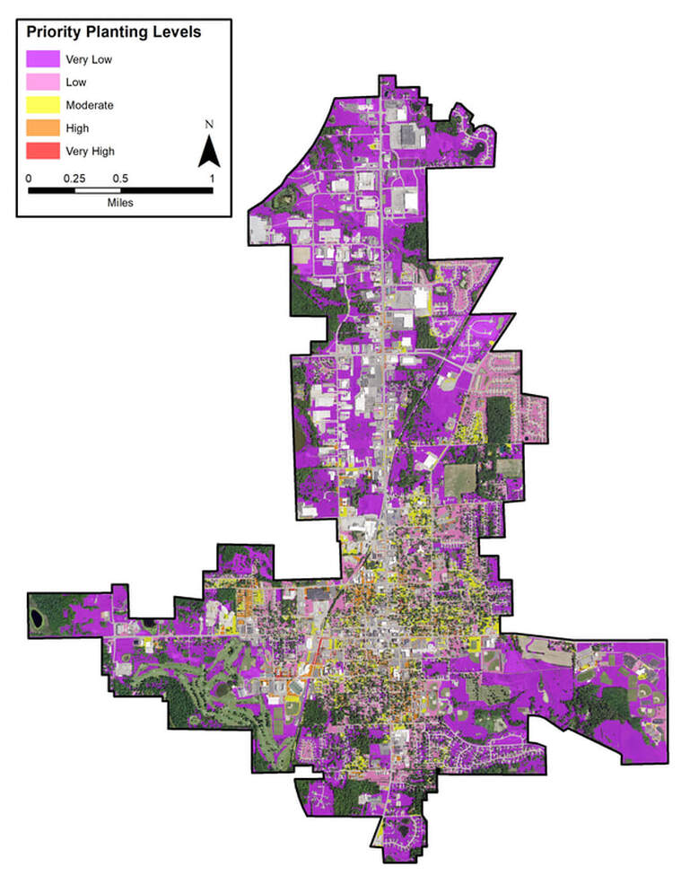
Figure 3A. Angola prioritized planting areas.
Canopy Percent by Census Block
Analysis of tree canopy percentage by census block can be used as a supplemental tool in determining which neighborhoods are in most need of new plantings (Figure 4A). For Angola, the canopy coverage by census block analysis correlates with the results of the priority planting area analysis. Many of the areas assigned a Moderate, High, or Very High planting priority are located in census blocks with less than 25% canopy coverage. Particularly noticeable is Angola’s city-center, which contains several blocks with less than 10% canopy coverage. Per the planting priority analysis, the city-center also exhibits numerous High and Very High Priority planting areas. Identifying census blocks with less than 10% canopy coverage which contain higher priority planting areas are prime target areas for maximizing tree benefits.
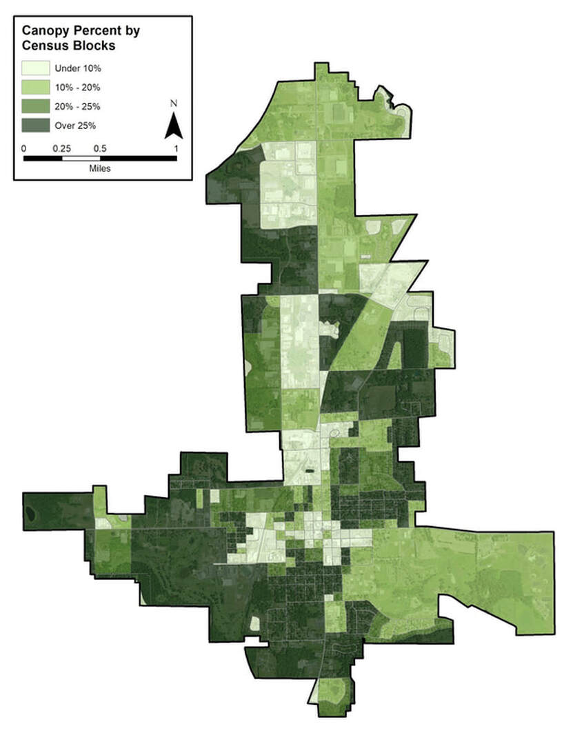
Figure 4A. Angola tree canopy by census block.
Canopy Percent by Right-of-way (ROW)
Canopy cover analysis of a city ROW can help provide insight into a segment of the community forest that a municipality can most directly affect: its public streets. By looking at the level of canopy coverage along individual ROWs, planners can identify specific streets within the community for planting efforts focused on improving canopy coverage and stormwater reduction. Oftentimes, the lowest percentage of ROW canopy is found along state routes and streets within commercial areas. In Angola, this observational trend holds true. Figure 5A demonstrates that the lowest percentages of ROW canopy are found in the commercial districts, in some neighborhoods in the northeast, on N Wayne Street (Indiana 127), and along East and West Maumee Street (US Route 20).
State roadways and commercial districts each present unique challenges for planting initiatives. Roadways might require partnerships between local and state authorities to ensure plantings efforts are appropriate, effective and compliant with any existing regulations. Planting efforts in commercial areas will require buy-in from the area businesses who may have concerns of trees blocking view of their signage. Regardless of the district or authority in charge, it’s important to ensure that correct trees, both in terms of species and size, are chosen to suit the planting spaces along the ROW. Remember the mantra “right tree, right place."
State roadways and commercial districts each present unique challenges for planting initiatives. Roadways might require partnerships between local and state authorities to ensure plantings efforts are appropriate, effective and compliant with any existing regulations. Planting efforts in commercial areas will require buy-in from the area businesses who may have concerns of trees blocking view of their signage. Regardless of the district or authority in charge, it’s important to ensure that correct trees, both in terms of species and size, are chosen to suit the planting spaces along the ROW. Remember the mantra “right tree, right place."
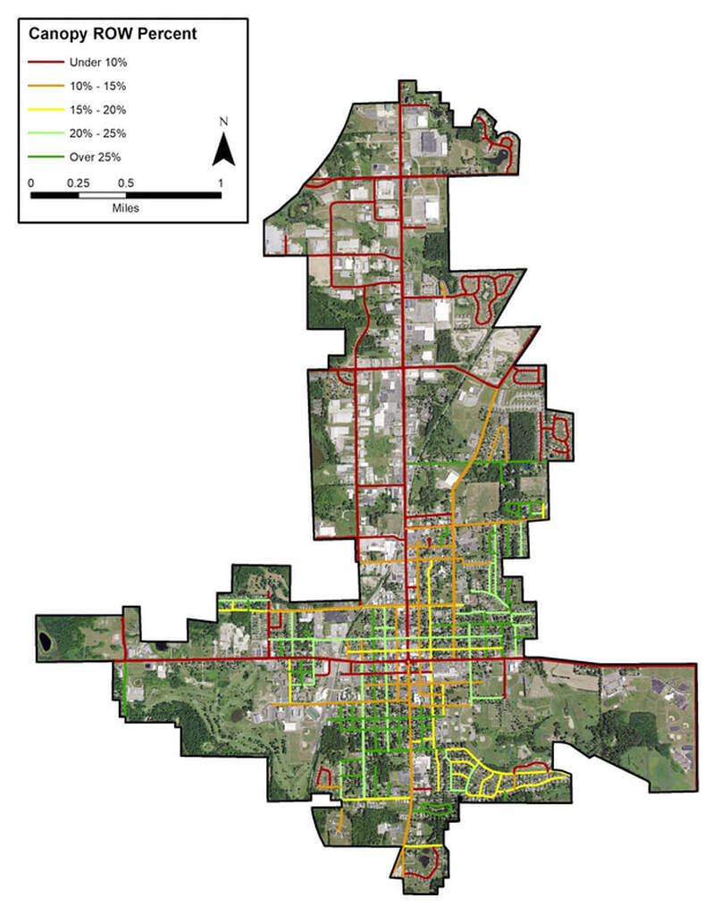
Figure 5A. Angola right-of-way canopy cover.
Ecosystem Benefits Analysis
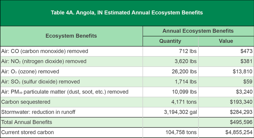
Community forests are important components of the ecosystem and provide quantifiable benefits. In total, Angola realizes an annual benefit of $495,596 from its trees (Table 4A). These annual benefits include $17,963 in reduction of air pollution, carbon sequestration equivalent to $193,340, and stormwater reduction valued at $284,293. Additionally, the city’s trees are estimated to have stored 104,758 tons of carbon over the course of their lifetime for an estimated total value of $4,855,254.
Custom Assessment: Tree Placement Analysis
The potential tree planting opportunities within Angola city limits were analyzed utilizing a tree placement model. This custom analysis models tree placement by randomly assigning trees of varying size-class within the previously identified planting priority areas. The model outputs report the number of large, medium and small mature-sized trees that could be planted within each planting priority rank category.
In Angola, the placement analysis model estimates a total of 4,234 trees that can be planted in areas with a planting priority rating of Moderate or above (Table 5A). Of these, 2,855 are small-maturing trees, 740 are medium-maturing, and 639 are large-maturing trees. Figure 6A shows a map of the City of Angola and planting locations for small, medium, and large trees within planting priority areas of Moderate, High, and Very High. Careful study of this analysis will help planners select both tree locations and tree species that will optimize community benefits.
In Angola, the placement analysis model estimates a total of 4,234 trees that can be planted in areas with a planting priority rating of Moderate or above (Table 5A). Of these, 2,855 are small-maturing trees, 740 are medium-maturing, and 639 are large-maturing trees. Figure 6A shows a map of the City of Angola and planting locations for small, medium, and large trees within planting priority areas of Moderate, High, and Very High. Careful study of this analysis will help planners select both tree locations and tree species that will optimize community benefits.
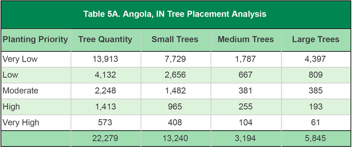
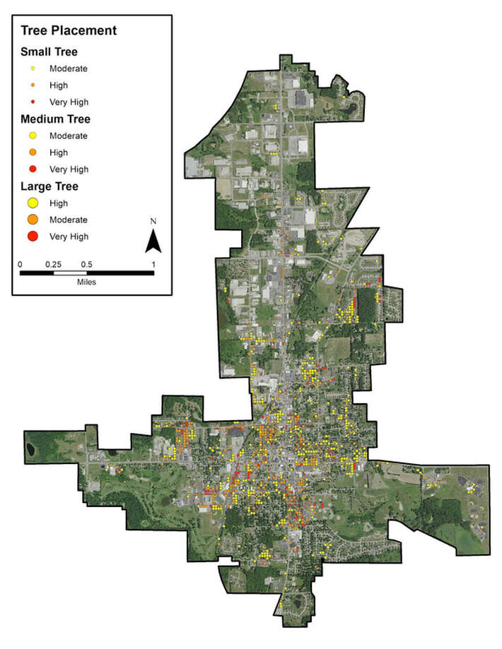
Figure 6A. Angola tree placement map.
